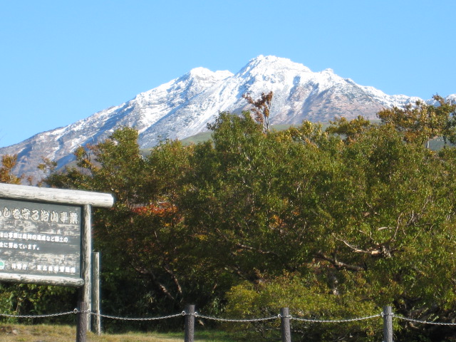
[:en]11_Mount Chokai[:ja]11_鳥海山[:]

[:en]%e9%b3%a5%e6%b5%b7%e5%b1%b1

11. Mount Chokai

location:  on the border of Akita and Yamagata prefectures (there are 2 trailheads for hiking to the top in Honjo Yuri) 

Chokai mountain is the second highest mountain in Tohoku, at 2236m, and faces The Japan Sea between Akita Prefecture and Yamagata Prefecture.
It is also known as “Dewa Fuji”  from the old name for this area (Dewa) and because of its beautiful outline which resembles Mount Fuji.
It used to be the focus of local people’s worship and was regarded as a fierce god of fire.  In fact, there is a lake called Choukaiko on the 7th station with many alpine plants around it.  A local legend says that a dragon lives here!
Mount Chokai is also renowned for its mountain flora and it appears in the prefectural song of Akita, in which it is described as  “graceful and peerless and unique”.
Mount Chokai is one of the most important of Akita’s many mountains and is mentioned in the school songs of elementary schools, junior high schools and high schools.
In September 2016 (Heisei 28), Mount Chokai was designated as a Geopark, together with the adjacent Tobishima island.
Interestingly, people from each area of Akita take pride in saying that their own view of Mount Chokai is the best.

keywords: nature, mountain, sightseeing
features:  magnificent, glacier,  mountain flora

%e9%b3%a5%e6%b5%b7%e5%b1%b1%e3%81%a8%e6%98%9f%e7%a9%ba

[:ja]%e9%b3%a5%e6%b5%b7%e5%b1%b1

名称 鳥海山(ちょうかいさん)

種別 自然 山  観光

場所 秋田県と山形県の県境に位置する(秋田県の登山口は、象潟と矢島口がある)

イメージ 雄大 以前は万年雪 花

概要

鳥海山は、日本海に面した標高2236mで東北では2番目の高さの山です。

秋田県と山形県の中間にあり、シルエットの美しさから「出羽富士」とも呼ばれる。古くから信仰を集め、近隣から荒ぶる火の神として崇められてきました。

7合目には竜が住むと言われている鳥海湖があり、その湖の周辺では多くの

高山植物を見ることができ、花の名山としても有名である。

また鳥海山は、「秀麗無比なる鳥海山よ・・・・」と県民歌にも代表される山で県内の小、中、高の学校の校歌にも良く登場する県内屈指の勇壮で美しい山である。

平成28年9月に日本海にある飛島とともに鳥海山はジオパークに認定されました。みんなそれぞれ自分の地域から見える鳥海山が最も美しいと自慢します。

T.TOGASHI

S.SATO

%e9%b3%a5%e6%b5%b7%e5%b1%b1%e3%81%a8%e6%98%9f%e7%a9%ba


[:]

[:en]12_Hottai-no-Taki Waterfall[:ja]12_法体の滝[:]

[:en]%e6%b3%95%e4%bd%93%e3%81%ae%e6%bb%9d-2

12. Hottai-no-Taki Waterfall

location:  Chokai Machi Momoyake, Yurihonjo – 40 minutes by car from Yashima railway station

The waterfall collects water from melting snow on Mount Chokai and the surrounding spring water.
It is also the source of Koyoshi River which flows through the Yuri area.
The waterfall drops in 3 sections:-
top section:  there is a trekking course at the top of the waterfall which leads to the trailhead for climbing Mount Chokai;
middle section: unusual holes of various sizes appear around the riverbed, which are of significant academic interest;
bottom section:  the main cascade at the bottom plunges into a large pool of water.
The overall length of the waterfall is 100m, with a width which varies between 3~30m.  The elevation from the highest point to the bottom is 57.4m.
In 1960 Hottai-no-Taki Waterfall was designated as a place of outstanding natural beauty by Akita Prefecture
The volume of water which cascades down the waterfall is remarkable, and visitors can experience its cold and clear water, which is a feature of this natural offering at the foot of Mount Chokai.

keywords:  nature, waterfall
features: cold water all year round, abundance of water, dynamic stream

written by S. Sato

%e6%b3%95%e4%bd%93%e3%81%ae%e6%bb%9d_%e7%b4%85%e8%91%89

[:ja]%e6%b3%95%e4%bd%93%e3%81%ae%e6%bb%9d-2

名称 法体の滝(ほったいのたき)

種別 自然 滝

場所 由利本荘市鳥海町百宅(ももやけ)

鳥海山ろく線矢島駅から車で40分(25Km)

イメージ 夏でも冷たい水、水量豊富、豪快な水流

概要

鳥海山の雪解け水と湧水を集めて流れる滝で、由利地方を流れる子吉川の源流となっている。三段で流れ落ちていて、

一の滝 上流部、トリッキングコースあり、登山口へ

二の滝 滝河床にみられる大小の穴(甌穴 おうけつ)が学術的に珍しい

三の滝 下流にある大きな滝で広場に連なる

から成る。流長100m、落差57.4m 滝幅3~30mの末広がりの名瀑。

豊富な水量と冷たい澄んだ水に驚きを感じます。鳥海山ろくに隠たこの滝で山からの恵みの水を実感して下さい。

S.SATO

%e6%b3%95%e4%bd%93%e3%81%ae%e6%bb%9d_%e7%b4%85%e8%91%89

[:]

[:en]13_Kujukushima Islands[:ja]13_九十九島[:]

[:en]%e4%b9%9d%e5%8d%81%e4%b9%9d%e5%b3%b6%ef%bc%92

13. Kujukushima Islands

location:  Kisakata, Nikaho City

After Mount Chokai erupted in 466 BC, lava flowed down into the shallow waters of the Japan Sea, thereby forming many small islands along the coast from this clash of hot molten rocks with sea water.
Over time sedimentation caused the shallow sea to divide into sand dunes, with the result that the coastal landscape was transformed into many lagoons around the group of islands.
Each of these small islands was thickly covered with pine trees, and this picturesque scene of many pine-clad islands became a feature of the Kisakata coastline.
The celebrated haiku poet Matsuo Basho visited the area and introduced these islands in “Oku-no-Hosomichi” (The Narrow Road to the Deep North) in the Edo Period.
However, in 1804, a dramatic change occured when a series of earthquakes caused the seabed to rise up and the water around the islands was pushed out to sea.  As a result, the 99 islands became landlocked, and have remained that way since then.
In spring and early summer, during the rice planting season, you can imagine the pre-earthquake scene of the ninety-nine islands because the surrounding rice fields are then filled with water.
Please visit the Michi-no-Eki Kisakata (Kisakata Roadside Station) and climb the observatory in Nemu-no-Oka so that you can enjoy the panoramic view of where the original islands stood.

keywords: nature, crustal movement
features:  islands in the countryside, geological activity, haiku poems

written by A. Wakabayashi

%e4%b9%9d%e5%8d%81%e4%b9%9d%e5%b3%b6%ef%bc%91

[:ja]%e4%b9%9d%e5%8d%81%e4%b9%9d%e5%b3%b6%ef%bc%92

名称 九十九島 (くじゅうくしま)

種別 自然 地殻変動

場所 にかほ市象潟

イメージ 田園の中の島々 地殻変動 俳句

概要

紀元前466年に鳥海山が噴火し、発生した大規模な山体崩壊による流れ山が日本海に流れ込み、浅い海と多くの小さな島々ができあがった。やがて堆積作用の結果、浅海は砂丘によって仕切られて潟湖ができた。その小さな島々には松が生い茂り、風光明媚な象潟の地形ができあがった。

文化元年(1804年)の象潟地震で海底が隆起し、陸地に島がある現在の景色になった。江戸時代の俳人松尾芭蕉の「奥の細道」にその島々が読まれている。

田植え時期は、周囲の田に水が張られ、従時の九十九島を想像できます。

九十九島の全体像が良く見える「道の駅象潟」ねむの丘展望台にも行ってみたい。

A.WAKABAYASHI

%e4%b9%9d%e5%8d%81%e4%b9%9d%e5%b3%b6%ef%bc%91

[:]

[:en]14_Mototaki Waterfall[:ja]14_元滝伏流水[:]

[:en]%e5%85%83%e6%bb%9d

14. Mototaki Waterfall and underground spring water

location:  Kisakata-aza-hongo, Nikaho City – 20 minutes from Kisakata railway station by car

Legend says that all the frozen snow on Mount Chokai was absorbed into the ground 800 years ago, where it remained dormant under volcanic rocks for many centuries and now gushes out through moss-covered rocks, such as at Mototaki Waterfall.
The rare landscape here has become a focal point for its beauty and was also chosen as one of the 100 purest water sources in Japan by the Japanese Ministry of the Environment.
The stream of underground spring water flows into a waterfall 30m wide and from a height of 5m.  The water never runs dry and the current flows down in different directions.  The water flies off the mossy rocks and leaves traces of beautiful lines.
The contrast of this clear water and the green moss is both beautiful to behold and therapeutic for the mind.
This underground spring water is Mother Nature’s gift from Mount Chokai to us.

keywords:  nature, underground water
features:  water source, negative ions, mysterious

written by Y. Otaki


[:ja]%e5%85%83%e6%bb%9d

名称 元滝伏流水(平成の水百選に選ばれている)

種別 自然 伏流水

場所 にかほ市象潟字本郷

象潟駅から車で20分

イメージ 水源 マイナスイオン、神秘

概要

元滝では約800年前の鳥海山の根雪が地中に染み込み、苔に覆われた岩の間から伏流水となって湧き出すといわれている。この珍しい景観は、「美しき水の郷」を象徴する風景で「平成の水百選」(環境省)に選ばれている。伏流水の幅は約30m、高さ5mほどある。

一年中枯れることのない水は、幾筋の線となって流れ落ちて、豊かな苔を育み、苔岩にはじけ飛んで美しいしずくの軌跡を描きます。
この白い水と緑の苔が大変きれいな滝で、心が癒されます。この伏流水は鳥海山からの私達への贈り物です。

Y.OTAKI


[:]

[:en]16_Naso-no-Shirataki Waterfall[:ja]16_奈曽の白滝[:]

[:en]%e5%a5%88%e6%9b%bd%e6%bb%9d

16. Naso-no-Shirataki Waterfall

location:   Kisakata Kamigou, Nikaho-city – 25minutes by bus from JR Kisakata railway station and a further 15-minute walk

Standing at 26m high and with a width of 15m, Naso-no-Shirataki waterfall is one of the great waterfalls in Akita.
The waterfall lies within the Chokai quasi-national park on the Naso River, whose water flows down from the nearby Mount Chokai.  With its abundance of water and natural environment, it was designated as a national scenic beauty spot in 1932.
At the entrance to the waterfall is Kinpou shrine, which has a large collection of cultural objects from the Heian Period of Japanese history (AD 794-1185).
After entering the precinct of this shrine, a stone path leads down to the river through old cedar trees and large rocks.  These rocks are thought to have been formed by lava after a volcanic eruption of Mount Chokai.
At the bottom of these steps the view opens up to reveal the cascading waterfall surrounded by trees.
You can gain a real sense of the energy and coolness of the waterfall near the basin.

keywords:  nature, waterfall
features:  full of water, negative ion

written by M. Takahashi


[:ja]%e5%a5%88%e6%9b%bd%e6%bb%9d

名称 奈曽の白滝(なそのしらたき)

種別 自然 滝

場所 にかほ市象潟上郷

JR象潟駅からバスで25分、降車後徒歩15分

イメージ 水量豊富 マイナスイオン

概要

奈曽の白滝は秋田を代表とする名瀑です。高さ26m、幅11mをほこり、水量が豊富で周囲の環境の良さから、国の名勝に指定されています。滝は2236メートルの鳥海山から流れる奈曽川にあり、一帯は鳥海国定公園に指定されております。

滝の入り口に、平安時代(AD794~1185)からの文化財を数多く収蔵する金峰神社があります。同神社の境内を通過して長い石段を下っていくと、老杉と鳥海山の溶岩と思われる巨石が点在しています。石段を下り終えると、木々に囲まれた滝の全容が目に出来ます。滝つぼの近くで、その迫力と清涼感を感じて下さい。

M.TAKAHASHI


[:]